 In honor of Lincoln’s 216th birthday (February 12, 1809), we offer several informational items for your reading enjoyment.
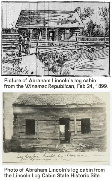
From the Winamac Republican, February 24, 1889
Some New and Interesting Facts from the Spot Where the Great President Spent Most of His Boyhood Years, from the Winamac Republican, February 24, 1899
The little old church at this point, the home of Abraham Lincoln’s boyhood days, is decorated, and Sunday, in the little edifice, the good old Southern Indiana “folk” of Lincoln City and the surrounding country will commemorate his ninetieth anniversary. Many of those who will gather beneath the roof Sunday morning remember him when he was an overgrown young man who held the record of the southern part of the State for logrolling, rail splitting, lifting and other early Indiana accomplishments, while there are a very few, now old and infirm, who remember him when he was a barefoot boy, too poor to go to school. Abe and his family were then known in the settlement as “a good fer nothin’ lot,” and in Kentucky, from where they had emigrated, they belonged to that class referred to by negroes as “poo’ white trash.”
There are many histories of Lincoln, many stories of his boyhood and tales of his privation in early life, but still, after reading all of them, when one enters this little village and stands surrounded by the landmarks of his early days, another and more interesting story than any that have been published comes to a visitor. Lincoln City is lost away among the hills of Spencer County – inaccessible almost to the traveler. It did not boast of a name until after the poor boy who spent his boyhood – from 7 to 21 years – here had become President of the nation and took his place in the brightest pages of the world’s history. Then people down “to the county seat” began to refer to the settlement as Lincoln City, and now it has a recognition on most maps of Indiana. Here on a knoll, lies buried Nancy Hanks, his mother. Over there in a forgotten grave lies Sally Bush, his stepmother and guiding angel, and all around are the landmarks of interest, each referring to a story of his boyhood days.
The story of Lincoln’ early life is materially different …
 The story of Lincoln’s early life, gathered here, is materially different in many respects from those which appear in publications. It is more to the successful man’s credit to tell the truth of his surroundings. It was along in the early part of the year 1816 – a few months before the State was admitted to the Union – that Thomas Lincoln, Nancy Hanks Lincoln, and their children, Nancy Hanks, aged 9, and Abraham, aged 7, appeared at the mouth of Anderson Creek, on the Kentucky side of the Ohio River. Nancy and Nancy, Jr., sat in the rude frontier wagon, in which was packed all of their earthly possessions, except an old cow, which Thomas and the son drove along behind.
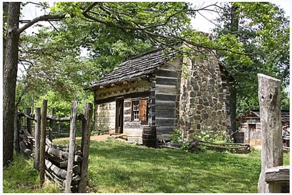
They crossed into the wilderness of Indiana and drove north into the Indian land. Fifteen miles back from the Ohio, they found a knoll, and there they stopped and made their home. This ground is Lincoln City of today. Thomas was a carpenter, and he managed to build a log cabin. He did not take the trouble, however, to cut in windows. He then made three three-legged stools and a table by turning a board slab, flat surface up, and putting in four sticks as legs. There was a bed made by poking poles into cracks in the logs and supporting the other ends in forked sticks. Over these poles were laid whip-sawed boards, and over these leaves, and then bear and deer skins and old clothes. This, with the exception of a Dutch oven and a skillet, was the entire household equipment.
Thomas Lincoln was anything but exemplary …

As he is remembered here, Thomas Lincoln was anything but exemplary. He was lazy to a very great degree and spent all of his time fishing and hunting. He only cultivated a half dozen acres of land, and his wife and children did all of the work. He was too lazy, or indisposed, to provide his house with necessities, and Abe, who slept in the loft, had to mount to his perch by pegs driven in the walls, because his father was too shiftless to make him a ladder. And with all due credit to Nancy Hanks, it must be admitted that she was little better than the father. They ruled their children by harsh methods, they were not cleanly and they had never cared for better things. Therefore, Abraham, when he was 9 years of age, had not learned to read or “figger,” and his sister, two years his senior, had not fared better.

It was possibly a good thing for the nation, as well as the boy, that, when he was 8 years old, his mother sickened and died of milk fever – a disease known to the frontier and now claimed to have its origin in poor sanitation. The father and son whipsawed lumber and made a crude box, into which the corpse was placed. Twenty settlers gathered at the Lincoln cabin and carried the coffin to a hillock in the virgin forest and lowered her to her last resting place. There was no one present who was capable of “saying a few words,” and that was deferred for some months, and then performed by an itinerant preacher.
Thomas had been a widower thirteen months …
 Thomas had been a widower thirteen months, when he took a notion to go over in Kentucky and see the folks where he had lived. There he found a widow, Sally Bush Johnston, an old sweetheart, who had married Johnston, his hated rival. He again proposed and was accepted. Thomas was not only the greatest storyteller of his section of Southern Indiana, but he had a poor regard for the truth at times, and he won his second wife by exaggerating his estate in Indiana to palatial proportions.
Sally was a woman of sterling qualities. She owed some money, and she insisted that the marriage be postponed until she had paid every cent. This was accomplished in one day and the marriage took place. She had been surrounded with the utensils of civilization – a bureau, a clothes chest, table and bed clothes, knives, forks and cooking equipment. Thomas insisted that she sell these and get the money, telling her he had all that was necessary. But she saw different and loaded them into a wagon and they started for Indiana. When she arrived here and saw her future home, she was heart-broken, and when she saw ill-kept and ill-fed Abe and Nancy she cried. Her own three children were in striking contrast.
When Abe saw the chairs, the knives and forks and other furnishings …
When Abe saw the chairs, the knives and forks and other furnishings unloaded, his eyes stood wide open, for he had never seen anything like it before. Sally Bush was a natural enemy of all chaos and disorder. She tossed the old dirty household effects out, made Thomas cut windows into the walls and put a floor into the cabin. She washed the walls and put the five children to cleaning up the premises. She took charge of Abe and Nancy and taught them the first principles of cleanliness and care, and love took the place of harsh words and ill treatment.
The great soul of the awkward, ignorant boy opened to her and the friendship which followed filled his whole life. He has said of her, “She was the woman who first made me feel like a human being.” He referred to her after he had become great as his “angel of a mother.” While on the other hand, her feelings toward him were summed up in her oft repeated, “Abe, my boy. He was the best boy I ever saw. He never disobeyed me; he never did wrong.” Her motherly feelings for him eclipse that which she even showed in the care of her own children. And after the news of his assassination was received, she never was the same.
Sally clothed Abe and Nancy cleanly …
 Sally clothed Abe and Nancy cleanly, and as well as her limited finances would permit, and put them in school. Neither had yet received even the rudimentary training, and they knew absolutely nothing about nature. They went four miles to school and had to walk. The boy readily grasped the instruction given, and within him was born the ambitions which made him President. After all the influences of those high in political authority, after all of the acquirements of the man himself, after all that might be considered are weighed, it becomes evident that it was this woman, with her ruling by love, her great fund of organizing powers, that gave to the world one of its greatest men.
Had it not been for her there is little doubt that Lincoln would not have risen higher than the illiterate woodchopper. She even made him a thinker as well as a student, and everything, as he often remarked, was due to her. Still, while the State of Indiana is engaged in a wordy dispute about assuming care of Nancy Hanks Lincoln’s grave – the woman who only gave him birth – the grave of his guiding angel is almost forgotten, and her memory has almost slipped from the public. Surely the women and mothers of America own her grave attention.
Abe was within two months of being 21 years old when he accompanied his father to Illinois and became a rail splitter by force of poverty …
Abe was within two months of being 21 years old when he accompanied his father to Illinois and became a rail splitter by force of poverty, and later a lawyer by constant night study. Thomas, the father, had showed improvement under the management of Sally. It was here, however, that Lincoln built his flat-boat and went down the Mississippi to New Orleans and first beheld slavery, and it was here, when he returned home, that he gave utterance to, “If I ever get a chance to hit that (slavery), I will hit it hard by the eternal God.” It was here he clerked in a general store; it was here that he first told his stories, and it was here that the Lincoln of history was molded.
Here and there are the decaying landmarks of his boyhood life. The last time he was here was when en route to Washington to occupy the place which the people of the nation had elected him to. He came to see Sally Bush, and she would have gone with him if she would have listened to him. The eyes of the nation were on him at that moment as they were never upon a President before or since, but still his heart was centered in the little cabin.
He had paid off the mortgage with the first money he had ever saved, and he sent her money as long as he lived. His devotion to his people and his old friends will be the grand theme which will be recalled from the pulpit at this, his old home, tomorrow. His schoolmates and others who knew him will gather to do him honor. Many will come from a distance. But most of them lay out in the little old cemetery and are with him in spirit. – E. I. Lewis, in St. Louis Globe-Democrat.
Tidbits from Wikipedia
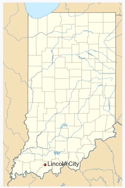
Lincoln City, Indiana
 Lincoln City is an unincorporated community in Carter Township, Spencer County in the southwestern part of the U.S. state of Indiana. It lies five minutes south of Interstate 64, northeast of Evansville, and approximately twenty miles north of the Ohio River. The Lincoln City post office has been in operation since 1892.
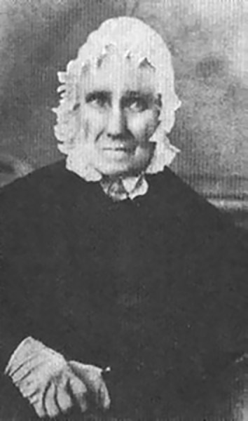
Lincoln City was laid out in 1872 when the railroad was extended to that point. The community was named for the Lincoln family. Nearby is the Nancy Hanks Lincoln Memorial, as well as the site of the Lincoln log cabin, built in 1816. President Abraham Lincoln spent much of his childhood (from the ages of 7 to 21) on this farm, and as a young man he practiced law at the nearby Spencer County courthouse. Also located in Lincoln City is the Lincoln Boyhood National Memorial, a national park managed by the National Park Service that includes a Living Historical Farm that attempts to recreate the early nineteenth-century period during which the Lincoln family lived in the area. The living-history farm is a working pioneer-style homestead with a cabin, outbuildings, split rail fences, animals, gardens, and field crops. NPS interpreters in period clothing perform a variety of activities typical of the 1820s, and the farm’s grounds are open year-round. The farm is staffed from mid-April through September full-time, and intermittently in October. The Lincoln Boyhood National Memorial is located on Highway 162 across from Lincoln State Park.
Spencer County, Indiana
 Spencer County was formed in 1818 from parts of Warrick County and Perry County. It was named for Captain Spier Spencer, killed at the Battle of Tippecanoe in 1811. He was also the namesake for Spencer, Indiana, the county seat of Owen County.
Abraham Lincoln lived in Spencer County from 1816 to 1830, between the ages of seven and twenty-one. Originally, the area his family settled in was in Perry County with Spencer County being formed almost two years later. His family moved to Illinois in 1830. The Lincoln Boyhood National Memorial is located at the site of the Lincoln family farm. In addition, the graves of his mother Nancy Lincoln and sister Sarah Lincoln Grigsby are located in Spencer County.
Lincoln Boyhood National Memorial
Lincoln Boyhood National Memorial is a United States presidential memorial and a National Historic Landmark District in Lincoln City, Indiana. It preserves the farm site where Abraham Lincoln lived with his family from 1816 to 1830. During that time, he grew from a 7-year-old boy to a 21-year-old man. His mother, Nancy Hanks Lincoln, and at least 27 other settlers were buried here in the Pioneer Cemetery. His sister Sarah Lincoln Grigsby was buried in the nearby Little Pigeon Baptist Church cemetery, across the highway at Lincoln State Park.
 Included in the park is the Lincoln Living Historical Farm. The Lincoln Boyhood Home was named a National Historic Landmark in 1960. In 2005 the site was visited by 147,443 people. On site is a visitor center, featuring a 15-minute orientation film about Lincoln’s time in Indiana, and museum and memorial halls. The site is located about ten minutes off the Interstate 64 / U.S. 231 junction and near the new U.S. 231 Route, named the Abraham Lincoln Memorial Parkway in his honor.
Lincoln State Park
Lincoln State Park is a state park of Indiana, United States. It is located in southern Indiana in Spencer County approximately 35 miles (56 km) east of Evansville.
The park was established in 1932 and encompasses 1,747 acres (707 ha). There are 10 miles (16 km) of trails in the park. Many of the recreational facilities found within the park were constructed by the Civilian Conservation Corps during the Great Depression. In addition to the Sarah Lincoln Woods Nature Preserve, there are two lakes, campgrounds, group cottages, and cabins.
The park provides access to many sites important to Abraham Lincoln during his childhood, including the Little Pigeon Creek Baptist Church and Cemetery, where his sister Sarah Lincoln Grigsby is buried; and the home of Colonel Jones a Civil War officer and merchant who employed Lincoln. Memorials were established to recognize Lincoln’s mother Nancy Hanks Lincoln, whose gravesite is now contained within the adjacent Lincoln Boyhood National Memorial. There is also an interpretive center. The park receives about 235,000 visitors annually.
The park is 1 of 14 Indiana State Parks that were in the path of totality for the April 8, 2024 solar eclipse, with 2 minutes and 5 seconds of totality.
Little Pigeon Baptist Church
 Little Pigeon Baptist Church: Noah Gordon donated the land, about a mile and a half from the Lincoln farm, for a church in 1820. In 1821, Abraham Lincoln’s father, Thomas Lincoln, was asked to oversee the construction of the Little Pigeon Baptist Church. Abraham, at age twelve, helped his father build the church. Thomas also constructed the cabinets and pulpit inside the church. The church, like other churches in the West, would not likely have had a college-trained minister. It was a Primitive Baptist or “Hard Shell Baptist” church.
Thomas joined the church with his second wife, Sarah Bush Lincoln, on June 7, 1823, and five days later became a trustee. The church membership was generally limited to married adults. Thomas’s daughter Sarah, for instance, was not made a member until 1826, shortly before her marriage. The Lincoln and Johnston children stayed at home when their parents went to church. Later, Abraham attended church. In 1825, the church decided to build a cemetery alongside the church. The church provided a means for a number of social gatherings for men and women.
It was called the Old Pigeon Church after several families, including the Grigsbys, split off from the church in 1840 and built a new Little Pigeon Baptist Church farther south. They split off from the old church due to differences of opinion about Sunday school and mission work.
The current structure is part of the state park and contains a cornerstone from the original church. Near the church is a small cemetery where the grave of Lincoln’s sister, Sarah Lincoln Grigsby, is located. A congregation no longer worships there.
Living on the Frontier
Frontier: Settlers cleared the forests of hickory and oak trees for farming. Within a few years the settlement was mostly farmland. The game in what Abraham Lincoln called the “unbroken forest” and “wild region” included bears, wolves, squirrels, partridges, hawks, wild cats, turkey, sparrows, and crows. Lincoln said in a poem:
When my father settled here,
‘Twas then the frontier line.
The panther’s scream, filled night with fear,
And bears preyed on the swine.
Some Items from FindAGrave
 Sarah “Sally” Bush Lincoln
- Birth 13 Dec 1788 Hardin County, Kentucky, USA
- Death 12 Apr 1869 (aged 80) Coles County, Illinois, USA
- Burial Thomas Lincoln Cemetery, Pleasant Grove Township, Coles County, Illinois, USA
President Abraham Lincoln’s Stepmother. She became Abraham Lincoln’s stepmother when he was nine years old. In 1816, she became a widow of Daniel Johnson, leaving her with three children. Thomas Lincoln became a widower in 1818 with two children. She was thirty-one years old, and he was ten years older. They had known each others for years. In 1819, returning to Kentucky, he simply knocked on her door one day in Hardin County, Kentucky, proposed marriage with the paying of her debts, and she accepted. They married on December 2, 1819. At first, this was a marriage made of convenience, not love. They were quickly married, packed Sarah’s belongings into a wagon, and headed for Thomas’ farm in Indiana. It was at this point, that Abraham and his sister learned that they had a new mother as well as three new siblings. While Thomas viewed his son’s studious ways as a waste of time, his new stepmother, although illiterate herself, encouraged his studies, which probably led to his lofty place in American history. According to the Federal Park’s information, they became close, while the distance between father and son widened. This was a blended family of nine in a small log cabin in the wildness with all the challenges that go with that situation. The Lincoln family migrated to Illinois in 1830, at which point,  Abraham parted and went his own way. Upon the death of his father in 1851, he did not attend the funeral, but continued to visit his stepmother periodically. The President-elect made one last visit to Sarah before he left for Washington, and then visited the grave of his father. An overnight visit on January 31, 1861, was the last time they would ever meet. As an adult, he called her “Mother” when speaking to others. When she heard of President Lincoln’s death, she mourned her stepson’s death publicly. Sarah continued to live at the Coles County farm until her death at age 80, leaving over twenty grandchildren to mourn her. She was interred beside her second husband, Thomas Lincoln. The Sarah Bush Lincoln Health Center in Coles County, Illinois, was named in her honor. She shares the same birthdate as Abraham Lincoln’s wife, Mary.
Inscription
 Father And Step-Mother
Of Our Martyred President
Their Humble But Worthy Home
Gave To The World
Abraham Lincoln
Erected By The Lions Club Of The State of Illinois
Nancy Elizabeth Hanks Lincoln
- Birth 5 Feb 1784 Antioch, Mineral County, West Virginia, USA
- Death 5 Oct 1818 (aged 34) Gentryville, Spencer County, Indiana, USA
- Burial Lincoln Boyhood National Memorial. Lincoln City, Spencer County, Indiana, USA

Mother of U.S. President Abraham Lincoln. She was a Virginia native, moving to Kentucky, where she met and married Thomas Lincoln. She gave birth to three children. The Lincolns moved to Spencer County in southern Indiana in 1816 and constructed a cabin on Little Pigeon Creek. She soon took ill and struggled between life and death for a week. She passed away a mere two years after arriving in Indiana. Her husband Thomas constructed a coffin from pine cut from the property. He took the body via a sled to a nearby pioneer hilltop cemetery near the Lincoln farm. There was no religious cleric in the region, so with Thomas Lincoln, his children, and a few neighbors, Nancy Lincoln was interred without a formal religious service. The grave has endured to the present time. Other graves in the tiny cemetery, as well as that of Nancy’s, were lost. Finally, a family friend erected a marker in an approximate location. Over the years, the site has been vandalized and allowed to become overgrown with trees and brush. Only when the fame of her son, President Lincoln, was established, was a concerted effort made to preserve the grave location. Life was hard in the wilderness, and a man with children could not remain without a wife for long. Thomas Lincoln quickly remarried. Abraham Lincoln was nine years old at the time of his mother’s death.
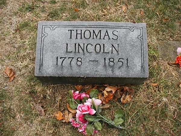
Thomas Lincoln
- Birth 6 Jan 1778 Rockingham County, Virginia, USA
- Death 17 Jan 1851 (aged 73) Coles County, Illinois, USA
- Burial Thomas Lincoln Cemetery, Pleasant Grove Township, Coles County, Illinois, USA
Father of U.S. President Abraham Lincoln. The migrations of Thomas were extensive. 1802 found him in Hardin County, Kentucky, where he married Nancy Hanks. That was the birthplace of their three children. In 1816, a move was made to southern Indiana onto a homestead claim where Nancy died and was buried. 1830 saw him on the move again, this time to Macon County, Illinois, with his second wife Sarah. He stayed only one year before moving to Coles County, Illinois. At this point Abraham, experiencing a strained relationship with his father, went out on his own. In terms of education Thomas lacked ambition, and never fully understood Abraham’s desire to read and learn. Here Thomas stayed for the rest of his life until his death at age 73. During his life, he was a farmer, a carpenter, and even worked for a time as a guard for county prisoners. After the future President parted company with his father, he did have some contact. By 1841, Thomas owned 120 acres of land, but eventually sold a third of his land to Abraham (now a successful lawyer) to get out of financial difficulty. Abe held on to this land for the purpose of providing a living place for his devoted stepmother in the event of his father’s death. In 1848, Thomas again received money from his son to save the rest of the land from a forced sale. Abraham did not attend the funeral of his father, but did visit the grave during a visit with his stepmother, with whom he kept a close relationship until his death.
64 Parishes
This item – not related to Indiana – was very interesting. Therefore, it was included!
Lincoln in Louisiana
In 1828 and 1831, a young Abraham Lincoln would visit New Orleans by way of a flatboat journey down the Mississippi River. He was nearly killed on his first excursion.
“64 Parishes” by Richard Campanella, Published: February 12, 2015, Last Updated: April 8, 2019
In 1828, a teenaged Abraham Lincoln guided a flatboat down the Mississippi River to New Orleans. The adventure marked his first visit to a major city and exposed him to the nation’s largest slave marketplace. It also nearly cost him his life, in a nighttime attack in the Louisiana plantation country. That trip, and a second one in 1831, would form the two longest journeys of Lincoln’s life, his only visits to the Deep South, and his foremost experience in a racially, culturally, and linguistically diverse urban environment.
Winter never fully arrived in 1828. Temperatures remained in their autumnal range, often rising to balminess and only occasionally dipping to seasonality or below. Rain fell from persistently cloudy skies, raising the waters of the Ohio and Mississippi. Trees greened prematurely; delighted farmers assumed an early spring and sowed seeds accordingly. Word from Louisiana had it that ears were growing on Indian corn—in February!—while harvestable bolls blossomed on Mississippi cotton plantations. “[E]very thing presents an appearance of June on the banks of the Mississippi,” marveled one Louisiana paper, even as it fretted about the river “attain[ing] a height that is truly alarming….” The Ohio had already exceeded its banks and flooded Shawnee Town in Illinois with six feet of water. Bad news for most folks, but good news for boatmen like Allen Gentry and Abraham Lincoln: high water meant swift sailing to New Orleans. First, however, they needed to build a flatboat.
Abe certainly possessed the construction skills …
Abe certainly possessed the construction skills: he “was thoroughly master of all the phases of frontier life,” reported a neighbor, including “woods craft” learned from his father.
The construction site was probably at Gentry’s Landing, a hundred-acre wooded parcel downriver from the Rockport, Indiana bluff. This area afforded timber, space, and a good spot to launch. Abe certainly possessed the construction skills: he “was thoroughly master of all the phases of frontier life,” reported a neighbor, including “woods craft” learned from his father.
The size of the Gentry-Lincoln flatboat may be estimated by an 1834 journal describing a flatboat launched from nearby Posey County. It measured eighty feet long and seventeen feet wide (1,360 square feet), manned by five men. A crew of two could typically handle a vessel roughly half that size, 40 or 45 feet long by 15 or so feet wide. Construction usually took one to two months, depending on the number of helpers and the availability of milled wood. (Hand-hewing significantly slowed down work, but also lowered costs.) Most Indiana men possessed basic carpentry skills and flatboat experience, making workers easy to find. Total costs typically ranged around one dollar per length-foot, but were probably minimal for this two-man homemade enterprise.
Exactly when the flatboat was launched is a critical piece of information …
 Exactly when Allen Gentry and Abraham Lincoln launched their flatboat from Rockport is a critical piece of information, because it directs us to the proper time window in which Lincoln would have arrived in New Orleans and thus enables us to reconstruct the daily city life to which he was exposed. While 100 percent of the historical evidence points to either an early springtime launch or a late-autumn/early-winter launch in the year 1828, neither alternative can be proven by primary historical documentation. There are no registries, no receipts, no contracts, and certainly no journals nailing down the date. But other sources of evidence and clues abound, and they support of the spring hypothesis. Allan Gentry’s wife Anna said so clearly in an 1865 interview, and neighbors Absolom Roby and John Romine concurred. Lincoln himself left behind clues that buttress the springtime launch, and said or phrased or implied nothing to contradict it. Numerous strands of contextual evidence lend additional support to a spring departure, as do the invitingly high river stages of spring 1828 and the extremely large number of flatboat landings documented in the New Orleans Bee and Argus newspapers.
We must now attempt to refine exactly when in spring 1828 Gentry and Lincoln departed. March is too early: despite some support in the historical record, this month has a demonstrably small time window in which to prove correct. May or June, on the other hand, are too late. This leaves April, as evidenced by Anna Gentry’s clear recollection of an April-to-June trip. When in April? A killer frost on April 5–7 suddenly ended the “False Spring” of 1828, plunging temperatures by forty degrees into the teens “accompanied with a light Snow.” Presumably the duo would have waited out that wintry blast. By April 12, afternoon temperatures hit the 80s F. Did they leave then? Anna Gentry drops a clue in her interview with Herndon:
Anna Gentry is interviewed …
One Evening Abe & myself were Sitting on the banks of the Ohio or on the [flat]boat Spoken of. I Said to Abe that the Moon was going down. He said, “Thats not so—it don’t really go down: it Seems So. The Earth turns from west to East and the revolution of the Earth Carries us under, as it were: we do the sinking…The moons sinking is only an appearance.
Only a young crescent moon sets in the evening sky, one to three days after the new moon. In April 1828, the new moon occurred on April 14, thus young crescents would have set in the early evenings of April 15–17. Lacking any further clues and in light of the above evidence, this researcher posits that Allen Gentry and Abraham Lincoln poled out of Rockport, Indiana, around Friday or Saturday, April 18 or 19, 1828.
Additional questions …
We must address a few other questions before reconstructing the voyage. First, what was their cargo? Amateur flatboat operations in this region carried the standard potpourri of Western produce—corn, oats, beans, pork, beef, venison, livestock, fowl, lumber, hemp, rope, tobacco, whiskey—sacked and barreled and caged and corralled and piled and bottled in organized chaos. Among boatmen, this was known as “mixed cargo,” as opposed to the “straight cargo” (single commodity) favored by large professional flatboat enterprises. Informants interviewed in 1865 remembered Lincoln had “[hauled] some of the bacon to the River”—smoked hog meat, in preparation for the voyage. A neighbor recalled buying pigs and corn from the Lincolns, leading one researcher to posit that the cargo probably comprised the two premier agricultural commodities of the region, “hogs and hominy.” Gentry family memories, recorded in the 1930s, cite “hogs” and typical Indiana “summer crops” as their ancestors’ standard flatboat cargo. Another family story, reported by 72-year-old E. Grant Gentry in 1936, claimed the flatboat carried “pork, corn in the ear, potatoes, some hay (was not a regular hay boat), and kraut in the barrel; apparently there were no hoop poles or tobacco….” Lincoln himself dropped a clue: “The nature of part of the cargo-load, as it was called,” he wrote in 1860, “made it necessary for [us] to linger and trade along the Sugar coast” of Louisiana. What might have been the nature of their cargo, that it would have traded better at the sugar plantations below Baton Rouge than in New Orleans proper? E. Grant Gentry testified that “the cargo was destined for…sugar planters who owned mules and negro slaves, the corn and hay being bought for the mules and the meat and potatoes for the slaves.” The cargo may well have included “barrel pork” (as opposed to bulk pork), which Southern planters demanded as a low-cost, high-energy food for slaves. Plantation caretakers constantly required a wide range of Western produce to maintain their village-like operations, and exchanged them for cotton or sugar, which flatboat men thence carried downriver. One 1824 report, for example, explained that flatboats navigated “from the Ohio, down the Mississippi to New Orleans, touching at the small towns in their way, and if possible disposing of a part of their multifarious cargo.” Thus Lincoln’s Sugar Coast clue may not mean too much, except that it rules out straight cargo (by referencing “part of the cargo-load”). After “lingering” along the coast, flatboats would then proceed on to New Orleans, where buyers for the standard commodities of cotton and sugar abounded. We know for certain that the cargo belonged to the Gentry family, and by extension to Allen Gentry; Abraham was merely a hired hand earning a set wage.
“[O]ne night they were attacked by seven negroes with intent to kill and rob them. They were hurt some in the melee, but succeeded in driving the negroes from the boat, and then ‘cut cable’ ‘weighed anchor’ and left.” —Abraham Lincoln
Second, did they travel at night? Nocturnal navigation could add thirty or more miles to daily progress. It also risked perils, especially given the high, fast waters of spring 1828. Both men would have needed to be at the ready with steering oar and pole all night, allowing no time for sleep. We know for certain no one else helped: “[I] and a son of the owner,” wrote Lincoln in 1860, “without other assistance, made the trip.” Given that neither man ranked as expert pilot—this was Gentry’s second trip and Lincoln’s first—the duo probably resigned themselves to tie up at night. Flatboatmen minimized the lost travel time by launching pre-dawn, landing after sunset, and taking advantage of moonlight whenever possible.
Third, at what velocity did Gentry and Lincoln travel? Flatboats generally floated at the speed of a brisk walk or jog, depending on river stage and their navigational trajectory within the channel. High springtime waters meant a steeper gradient to the Gulf and flow rates of five or six miles per hour or more. When the river ran low (late summer through early winter), flow rates dropped to half or two-thirds the springtime pace. But 1828 water levels ranked exceptionally high and swift. A report field from St. Francisville, Louisiana, on March 8 stated that
[t]he Mississippi river is now from 2 to 4 inches higher at this place than comes within the memory of man…. As the river is still rising, and as the highest flood is rarely ever earlier that the end of April, may we not yet see it this spring as high as it was in 1780…when…it was at least three feet higher than it now is…? Two crevasses have [already] been made at Point Coupee….
This level roughly equates, according to modern-day measurements, to surface velocities averaging 5.2 to 6.0 miles per hour, and peaking at 6.7 to 7.9 miles per hour. Friction and occasionally strong headwinds would reduce this speed somewhat, such that we may reasonably assume a 5.5-mile-per-hour flatboat speed for the springtime launch scenario. If we assume twelve hours of travel per day (daylight in this region and season lasts thirteen to fourteen hours, minus time for launching, docking, problems, and other stops), we estimate progress at around 66 miles per day.
Gentry’s Landing
Gentry’s Landing at Rockport, lying between river miles 857 and 858 as enumerated from Pittsburgh, marked mile zero for Allen Gentry and Abraham Lincoln as they poled their flatboat into the gray Ohio River dawn, around Friday or Saturday, April 18–19, 1828. They launched carefully into the Ohio’s tricky “riffles” (ripples), something that Lincoln would later describe as a key skill for successful navigation. Within hours, he expanded his personal geography, laying eyes on terrain he had never seen before. The free North lay to their right; the slave South to their left. Gentry, the veteran, probably took pride in pointing features out to his friend. While the arctic blast two weeks earlier had killed nascent vegetation, forests and fields were now rejuvenating with new life, and it looked beautiful.
Danger lay below the beauty. Islands with sandy-bottomed aprons could trap a loaded flatboat beyond the capacity of two men to free it. Experienced boatmen watched for them assiduously—even in high water, which tended to mask and relocate obstacles, more so than eliminate them. Along with large towns, major confluences, prominent topographic features, and distinctive structures, islands served as mile markers and metrics of trip progress.
As April drew to a close, Gentry and Lincoln, unbeknownst to them, entered Louisiana waters. The Mississippi by this time finally ceased rising; still extraordinarily high and swift, the river would fall slightly by about eight inches during the remainder of their journey. The scenery remained undistinguished until shortly after the Yazoo River joined the Mississippi from the east, at which point a series of rugged hills and plunging ravines drew close to the river. Atop sat the community known by the Spanish as Nogales and by early Anglos as Walnut Hills (855th mile of the journey, 591st down the Mississippi, around April 30–May 1), until the Vick family and others from the New Jersey region settled there in 1820. By 1828, the well-situated city of Vicksburg commanded that lofty perch over the Mississippi. Conceivably it created a lasting mental image upon which Lincoln could draw thirty-five years later, when the fate of the nation rested in part on military action under his command here. Vicksburg’s landing, like most others, lay partially underwater in the spring of 1828.
Lincoln was entering the heart of the Slave South for the first time in his life
With the wilderness of the inland delta behind him, Abraham Lincoln was now entering the heart of the Slave South for the first time in his life. He witnessed it from a river-landing perspective, and most assuredly saw numerous slaves in transit and in the fields well before arriving at New Orleans.
While professional flatboatmen with clients in New Orleans had no choice but to beeline to their big-city agents, amateur or speculative expeditions often traded en route. Some “worked the river” in methodical steps—loose cable, float downstream, pole in, drop anchor, tie-up, haggle, sell, loose cable—repeatedly, from plantation to village and onward. One flatboatman made “some eight trips down the Mississippi…selling produce at all the points from Memphis to New Orleans.” Trading before reaching New Orleans offered certain advantages. It put hard cash in pockets right away. It could also dramatically shorten the expedition, saving time and expenses while minimizing risk. But trading en route could also yield lower prices and weaker profits. And it eliminated the long-awaited chance to “see the elephant” and partake of New Orleans’ delights. Some flatboatmen got the best of both worlds by selling upcountry produce en route, re-filling the vacated deck space with locally gathered firewood or Southern commodities such as cotton and sugar, then proceeding to sell them in New Orleans.
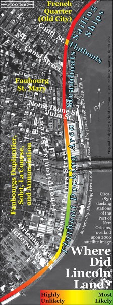
Richard Campanella identifies the area mapped in green tones, on the east bank of the Mississippi near the present-day town of Convent, as the most likely site of attack upon Lincoln. The site is a few hundred feet upriver from present-day St. Michael’s Church.
Natchez
Gentry and Lincoln drew closer to the world of high culture as they approached the unquestioned queen of the Mississippi bluff cities: Natchez. They arrived around May 2–3, two weeks after departure, 959 miles into their journey and 695 miles down the Mississippi. Established as Fort Rosalie in 1716 by the same man (Bienville) who founded New Orleans two years later, Natchez rose by the early 19th century to rank among the most important and wealthiest enclaves in the Southwest. By the time Lincoln arrived in 1828, the city had recovered from a series of devastating epidemics, and was poised for an era of economic and urban expansion. Flatboatmen approaching the city would catch sight of magnificent new lighthouse mounted atop light-colored earthen cliffs “clothed with clouds of foliage,” set among the spires and rooftops on the 200-foot-high hill. Their world, however, awaited them at the landing—“Natchez Under the Hill,” as it has long been called—where, according to a mid-1830s observer,
several hundred flatboats lined the levee, which was piled for two thirds of a mile with articles of export and import, the stores were crowded with goods and customers, and the throng was as dense as that in the busiest section of New Orleans.
Others pondered the irony of the Great Emancipator nearly perishing at the hands of the very people he would later liberate, and wondered if some attackers survived long enough to be freed by their victim.
Poling out of Natchez set Gentry and Lincoln on the final 300-mile stint of their 1300-mile journey. Pebble-bottomed tributaries such as St. Catherine’s Creek and the Homochitto River intercepted their passage on the hilly Mississippi side to the east, while bottomland forest and the occasional cotton plantation dominated the flat Louisiana side to the west. Fort Adams, a military outpost dating to colonial times and now a small settlement, marked roughly the thousandth mile since their Rockport launch. A few miles later they passed the famous 31st Parallel, a former international border that now demarcated the Mississippi /Louisiana state line. They were now entirely in Louisiana. Straight west of that invisible demarcation, muddy water borne in the Rocky Mountains of Mexico (New Mexico today) flowed in from the Natchitoches plantation region. This was the Red River, the last major tributary from the western side of the valley to join the Mississippi.
Bayou Chaffalio
Immediately below the Red River lay a confusing and potentially dangerous fork. “Be careful that you keep pretty close to the left [eastern] shore from Red river,” warned The Navigator, to avoid being drawn into this current, which runs out on the right shore with great rapidity. This is the first large body of water which leaves the Mississippi, and falls by a regular and separate channel into the Gulf of Mexico.
This was Bayou Chaffalio, today’s Atchafalaya River, the first distributary (that is, water flowing out of the main channel) of the lower Mississippi. Steering into the east prong of the fork, the men’s attention would have been caught by an “astonishing bridge” of trees, branches, and debris drawn out of the Mississippi by the Atchafalaya’s current. So dense and matted was the logjam—at the 1,032nd mile of the trip, 768th on the Mississippi, reached May 3–4—that “cattle and horses are driven over it.” The eighty-mile-long Red River Raft wreaked hydrological havoc on the area’s ecology under normal conditions, let along during high water. By one 1828 estimate, “the enormous quantity of brush, trunks of trees, &c…[had] gained at least one mile per annum;” and “back[ed up] the water upon the land for many miles,” making “a lake of what was before a prairie. The forests too…are often killed by the overflow of water, and after standing for a few years with their roots, submersed, the trees become rotten and fall,” thus worsening the blockage. The logjam also frustrated economic interests in the Acadian (Cajun) and Red River regions, by limiting direct navigational access to points south. To a problem-solving mind, the situation cried out for intervention.
Old River Meander …
Navigation interests on the Mississippi were additionally frustrated by the circuitous Old River meander, which lengthened travel time by hours. Rivermen hoped someday to avoid this loop by excavating the so-called Great Cut-Off across a swampy five-mile neck that separated the two yawning meanders (as occurred naturally in 1722 at nearby False River). Over the next decade, the Old River cut-off would be excavated and the Red River logjam would be cleared. Both internal improvements tremendously aided river interests and economic development, but also instigated a sequence of hydrological processes that would seriously threaten southeastern Louisiana and New Orleans a century later.
Bayou Sara
The busy little port of Bayou Sara, named for one of the last significant tributaries draining into the Mississippi, formed another “under-the-hill” landing typical of the east-bank bluffs below Vicksburg. Bayou Sara’s higher inland section was actually a separate town, St. Francisville, known for its serene beauty and the prosperity of the surrounding West Feliciana cotton country. This undulating region deviated from the rest of southern Louisiana in that English-speaking Anglo-American Protestants predominated over Franco-American Creoles and Acadians. The opposite was the case on the flat western side of the river, the Point Coupée region, which represented Gentry’s and Lincoln’s first encounter with an extensive, century-old Francophone Catholic region in Louisiana. The physical, cultural, and agrarian landscape changed along with the ethnic makeup, as The Navigator explained in 1814:
Here commences the embankment or Levee on the right [western] side of the river, and continues down to New Orleans, and it is here where the beauty of the Mississippi and the delightful prospect of the country open to view. [The banks from here], and from Baton Rouge on the left side down to the city of Orleans, have the appearance of one continued village of handsome and neatly built…frame buildings of one story high…stand[ing] considerably elevated on piles or pickets from the ground, are well painted and nicely surrounded with orange trees, whose fragrance add much delight to the scenery.
Another observer described the French Louisiana sugar manors as “large square edifices with double piazzas, and surrounded by orange and other evergreen trees [and] the extensive brick ‘sucriene’ or sugar house.” This arrangement differed from the “unpretending cottages [with] the humble wooden ‘gin’” of the Anglo-Louisiana cotton landscape on the eastern side of the river. That latter environment petered out at Port Hudson—last of the bluff landings—and at nearby Profit’s Island, the penultimate of the pesky atolls. The topography to the east now tapered off from bluffs with white-faced cliffs to low forested terraces, drained by the very last tributary of the Mississippi Valley, Baton Rouge Bayou. Below this stream sat the small city with that circa-1699 name, still years away from becoming the capital of Louisiana. Baton Rouge did, however, host the United States Barracks, a recently erected complex of five two-storied structures arranged in the shape of a pentagon, serving officers and soldiers deployed to the Southwest under the command of Lt. Col. Zachary Taylor. With pearl-white classical columns gleaming on the terrace, the Barracks regularly caught rivermen’s attention.
It is no exaggeration to say that Lincoln came very close to being murdered in Louisiana.
An intriguing legend posits that Lincoln did more than merely gaze at the Barracks from afar. The story seems to have originated with college professor and Confederate veteran Col. David French Boyd, who served as president of Louisiana State University when the institution occupied the decommissioned Barracks in the late 1800s. Boyd perused old garrison papers and recorded the notable military figures listed as visitors, among them the Marquis de Lafayette, Ulysses S. Grant, Robert E. Lee, Thomas J. “Stonewall” Jackson, George A. Custer, and others. Boyd claimed to have identified two other famous names in the papers, each denoted as “civilian” and undated. One was Jefferson Davis; the other was Abraham Lincoln. If true, the record would form the only surviving first-hand vestige of Lincoln in Louisiana. This researcher has been unable to find the “garrison records” that Boyd inspected and thus cannot verify his claim. Intuition, however, works against it. The notion of an anonymous poor young flatboatman visiting a restricted military facility, signing in, and perhaps even spending the night seems highly improbable, not to mention inexplicable. Why would he leave the flatboat? Why would he even approach the barracks, and why would the guards allow the ill-clad youth in? Even if Boyd correctly identified Lincoln’s name, it does not follow that Lincoln visited the Baton Rouge Barracks. Both Abraham Lincoln and Jefferson Davis served in the Blackhawk War (1832), as did former barracks commander Zachary Taylor. War records might have gotten mixed up with barracks records.
After departing Baton Rouge around May 4, Gentry and Lincoln floated out of the alluvial valley of the Mississippi River and entered its deltaic plain. No longer would “hills (like the oasis of the desert) relieve the eye of the traveller long wearied with the level shores,” as one visitor described the topographical transition. The banks—called natural levees—now lay above the surrounding landscape, forming the region’s highest terrestrial surfaces; cypress swamp, saline marsh, and salt water lay beyond. The Mississippi River in its deltaic plain no longer collected water through tributaries but shed it, through distributaries such as bayous Manchac, Plaquemine, and Lafourche (“the fork”). This was Louisiana’s legendary “sugar coast,” home to plantation after plantation after plantation, with their manor houses fronting the river and dependencies, slave cabins, and “long lots” of sugar cane stretching toward the backswamp. The sugar coast claimed many of the nation’s wealthiest planters, and the region had one of the highest concentrations of slaves (if not the highest) in North America. To visitors arriving from upriver, Louisiana seemed more Afro-Caribbean than American, more French than English, more Catholic than Protestant, more tropical than temperate. It certainly grew more sugar cane than cotton (or corn or tobacco or anything else, probably combined). To an upcountry newcomer, the region felt exotic; its society came across as foreign and unknowable. The sense of mystery bred anticipation for the urban culmination that lay ahead.
But Allen Gentry and Abraham Lincoln were here for business, not touring. Like other flatboatmen, they decided—or more likely, had been instructed by James Gentry—to remove their piloting hats at this point of the journey and don their salesmen hats. Lincoln himself stated that, during his “first trip upon a flat-boat to New-Orleans…[t]he nature of part of the cargo-load…made it necessary for [us] to linger and trade along the Sugar coast.” Flatboatmen would pole along the slackwater edge of the river, drop anchor, “cable up” at the plantation landing, inquire for the manager, and offer to trade. “We are now in the sugar belt,” wrote one flatboatmen upon reaching the same region; “[t]he river is always dotted with up-country boats, sometimes a score being in sight at once.” They shared the banks with washerwomen, water-retrievers, fishermen—and a sight that startled one particular traveler of this same era:
I was surprised to see the swarms of children of all colours that issued from these [plantation] abodes. In infancy, the progeny of the slave, and that of his master, seem to know no distinction; they mix in their sports, and appear as fond of each other, as the brothers and sisters of one family….
After lingering and trading along the sugar coast for a roughly a week (starting, in this estimated chronology, around May 5), Gentry and Lincoln tied up for the evening of May 12 or 13 approximately sixty miles above New Orleans. That night would prove to be the most memorable, and dangerous, of Lincoln’s entire river career.
Lincoln recalled many years later what happened next …
Using his characteristic brevity and speaking of himself and Gentry in the third person plural, Lincoln recalled many years later what happened next:
[O]ne night they were attacked by seven negroes with intent to kill and rob them. They were hurt some in the melee, but succeeded in driving the negroes from the boat, and then “cut cable” “weighed anchor” and left.
Biographer William Dean Howells offered a compatible account of the incident, worth quoting because Lincoln personally reviewed Howells’ draft and tacitly validated that which he did not edit:
“One night, having tied up their ‘cumbrous boat,’ near a solitary plantation on the sugar coast, they were attacked and boarded by seven stalwart negroes; but Lincoln and his comrade, after a severe contest in which both were hurt, succeeded in beating their assailants and driving them from the boat. After which they weighed what anchor they had, as speedily as possible, and gave themselves to the middle current again.
Neighbors interviewed by William Herndon in 1865 readily recalled the incident, suggesting that Gentry and Lincoln featured it in fireside stories about their New Orleans adventure. “Lincoln was attacked by the Negroes,” recalled neighbors;
no doubt of this—Abe told me so—Saw the scar myself.—Suppose at the Wade Hampton farm or near by—probably below at a widow’s farm.
Anna Gentry shed more light on the incident, which her spouse Allen experienced firsthand:
When my husband & L[incoln] went down the river they were attacked by Negroes—Some Say Wade Hamptons Negroes, but I think not: the place was below that called Mdme Bushams Plantation 6 M below Baton Rouche—Abe fought the Negroes—got them off the boat—pretended to have guns—had none—the Negroes had hickory Clubs—my husband said “Lincoln get the guns and Shoot[”]—the Negroes took alarm and left.
John R. Dougherty, an old friend of Allen Gentry whom Herndon interviewed on the same day as Anna, corroborated her details with first-person knowledge of the site:
Gentry has Shown me the place where the niggers attacked him and Lincoln. The place is not Wade Hamptons—but was at Mdme Bushans Plantation about 6 M below Baton Rouche.
Dougherty was not the only Lincoln associate with personal connections to the site; Lincoln’s cousin John Hanks claimed to be in the vicinity when the attack occurred in 1828. “I was down the River when Negroes tried to Rob Lincoln’s boat,” he told Herndon in 1865, but “did not see it.”
Where exactly did the Louisiana incident occur?
Where exactly did the Louisiana incident occur? We have three waypoints to triangulate off: (1) a plantation located below Wade Hampton’s place, specifically one (2) affiliated with a woman named “Busham” or “Bushan,” (3) located around six miles below Baton Rouge. Wade Hampton’s sugar plantation remains a well-known landmark today, marked by the magnificent Houmas House in Burnside, which was built twelve years after the incident to replace the antecedent house. Just below the Hampton place, we seek a woman-affiliated plantation whose surname could only be remembered as sounding like “Busham” or “Bushan.” A parish census in 1829, the federal census of 1830, and detailed plantation maps made in 1847 and 1858 record no such surnames, nor a woman-led household in the specified location. But Herndon apparently gleaned additional information that did not appear in his interview notes, because when he published Herndon’s Lincoln in 1889, he reported “the plantation” belonging not to “Busham” or “Bushan,” but to the rhyming “Duchesne”—specifically “Madame Duchesne.” That surname, common in France but not in French Louisiana, also fails to appear in the aforementioned sources. The 1829 St. James Parish Census does list a Dufresne family (with nineteen slaves), but they do not align with our criteria. The 1830 federal census records only two Duchesne families throughout the entire region, both from New Orleans proper.
Yet there was a Duchesne woman affiliated with this area: French-born Rose Philippine Duchesne (1769–1852), who in 1825 founded the Convent of the Sacred Heart (St. Michael’s) in present-day Convent, located twelve miles below the Hampton Plantation. Duchesne established Catholic missions, orphanages, convents, and schools for the American branch of the Society of the Sacred Heart, focusing on the Francophone regions of St. Louis and South Louisiana. She became well-known and well-loved in those areas; people called her “Mother Duchesne,” and the institutions she founded became known as “Mother Duchesne’s convent,” “Mother Duchesne’s school,” etc., even if she did not reside there. (In fact, Duchense was on assignment in St. Louis when Gentry and Lincoln floated south, and was recorded by the 1830 census as residing in a convent in that Missouri city. ) Mother Rose Philippine Duchesne was canonized a saint by the Catholic Church in 1988; a shrine in St. Charles, Missouri entombs her remains today.
It is plausible that the property affiliated with the woman whose name sounded like “Busham,” “Bushan,” or “Duchesne” was in fact Mother Duchesne’s convent. Gentry and Lincoln may have heard that name from passersby or river traders, and reasonably assumed it was a plantation, notable because it was owned by a woman. The convent itself certainly resembled a large plantation house of the era (see photograph in graphical insert). Thus, Mother Duchesne’s convent, after thirty-seven years of Indiana storytelling, became “Mdme Bushans Plantation.” No other explanation has come to light.
Some inconstancies …
We have one final problem in situating Lincoln’s Louisiana melee: Wade Hampton’s plantation is not located six miles below Baton Rouge, neither by terrestrial nor riverine measure—but exactly sixty river miles. Just as Indiana storytelling over many years may have converted “Bushan” to “Duchesne,” it also may have shifted “sixty” to “six.” It is worth noting that the countryside located six river miles below Baton Rouge lies only slightly beyond the cotton-dominant terraces and bluffs of the Mississippi River’s lowermost alluvial valley, and barely onto the sugar-dominant deltaic plain. Sixty miles below, however, brings one to the heart of the Louisiana sugar region. Given that Lincoln said he and Gentry “linger[ed] and trad[ed] along the Sugar coast” before the attack occurred, it sounds as though they were deep into sugar country, not recently arrived at its brink.
Allen Gentry and Abraham Lincoln had finally reached New Orleans, after 1,009 miles on the Mississippi and a grand total of 1,273 river miles since departing Rockport.
Researcher’s conclusions …
In sum, then, this researcher posits that Gentry and Lincoln were attacked near, of all things, a convent and girls’ school founded by a future American saint. We can say with greater confidence that the melee occurred within St. James Parish, sixty to seventy-two miles downriver from Baton Rouge, on the east bank of the river (as evidenced by all three of our waypoints: Baton Rouge, Hampton’s plantation, and Duchesne’s convent). Some biographers position the incident as having occurred near Bayou Lafourche and Donaldsonville, but those features sit across the river and a few miles above where all evidence indicates.
Who were the attackers? Numerical probability suggests they were slaves from a nearby plantation. Circumstances, however, imply they might have been runaways. Fugitive slaves were desperate for resources, and (arguably) more inclined to run the risk of stealing to survive. Apparently the attackers spoke English, since they understood Gentry’s holler to “get the guns,” and not a single source mentions French words flying. This suggests the men were “American” slaves, as opposed to the French-speaking Creole slaves who predominated on the sugar coast—thus making the fugitive theory slightly more plausible. (Only a few days after the incident, the local sheriff jailed three medium-build “American negro” men, ages 24–32 and speaking English only, who were in St. James Parish “without any free papers.” )
Legions of Lincoln biographers have imparted dramatic detail into the tussle. Others pondered the irony of the Great Emancipator nearly perishing at the hands of the very people he would later liberate, and wondered if some attackers survived long enough to be freed by their victim. Retellings in modern-day articles and travelogues often de-racialize the incident, describing the attackers as “seven men.” Others ignore it altogether, perhaps for the inconvenient twist it inflicts upon the traditional black-victimhood narrative associated with Lincoln’s New Orleans experience. One writer took another tactic, explaining, with zero evidence, that the thieves were really “half-starved slaves of a no-good plantation owner,” and went so far as to fabricate Lincoln saying, “I wish we had fed them instead of fighting them …. their owner is really more to blame than they,” despite Lincoln’s actual testimony of their lethal intentions.
Insights into the nature of race relations
On a different level, the incident provides insights into the nature of race relations and slavery in this time and place. Blacks attacking whites contradicts standard notions about the rigidity of racial hierarchies in the antebellum South—a hierarchy that, particularly in the New Orleans area, was more rigid de jure than de facto. On an ethical level, one may view the incident as producing not seven culprits and two victims, nor vice versa, but rather nine victims—victims of the institution of slavery and the violent desperation it engendered. On a practical level, we learn from the incident two details on the flatboat voyage itself: that the men traveled unarmed, and that they indeed avoided nocturnal navigation by tying up at night.
Some say Lincoln received a lasting scar above his right ear from the fight; others say the wound landed above his right eye, although one is not readily apparent in photographs. One informant said Lincoln specifically showed him the scar. The memory of the incident certainly lasted a lifetime, and that is perhaps the most significant message we can take away from this episode: according to Lincoln’s public autobiographical notes, the attack, and not slavery or slave trading, formed the single most salient recollection of both his Louisiana voyages. (Private statements were a different matter; more on this later.) It is no exaggeration to say that Lincoln came very close to being murdered in Louisiana. The incident may also underlie an unverified story that Lincoln acquired during his New Orleans trip “a strange fixation—that people were trying to kill him.”
Nursing their wounds, the shaken and bloodied men made off in the darkness and continued downriver. The rising sun revealed plantation houses—some modest, some palatial—fronting both banks at a frequency of eight or ten per mile and set back by few hundred feet from what one traveler described as the river’s “low and slimy shore.” Lacking topographic landmarks, rivermen used planters’ houses as milestones: Bayley’s, Arnold’s, Forteus’, Barange’s—“said to be the handsomest on the river.” Surely Gentry and Lincoln saw the ubiquitous lines of whitewashed slave cabins behind each planter’s residence (levee heights were far lower than they are now), but they may not have seen multitudes of slaves in the cane fields. At this time in May, Louisiana sugar cane began to develop “joints” and required little field labor until “October or November, when they cut, grind and boil the cane….”
The parade of homes …
As Gentry and Lincoln steered downriver, the passing parade of plantation houses occasionally gave way to clusters of humble cottages. Then the parade resumed, in layered sequence: manor house in front of dependencies and sheds, in front of slave cabins, in front of cane fields, with oaks, fruit orchards, and gardens on either side. Church steeples punctuated the riverside landscape: Contrell’s Church and Bona Cara [Bonnet Carre] Church marked the 942nd and 960th mile down the Mississippi, while the oft-noted Red Church (978th mile) lay halfway between the distinctive West Indian–style double-pitched roofs of the colonial-era Ormond and Destrehan plantations (both of which still stand). Simple wooden cottages appeared in isolation amid fenced gardens—then in greater densities, then merging into contiguous villages, separated by fewer and fewer agrarian expanses. Shipping traffic increased; more and more Gentry and Lincoln found themselves dodging and evading other vessels. Malodorous and noisy operations—steam-powered saw mills, sugar refineries, distilleries, soap factories, tallow chandlers (renderers of animal parts for candle-making)—indicated a proximate metropolis. A cacophony of distant whistles, shouts, bells, horns, hoof beats, and hammer blows carried across the 2,000-foot-wide river, growing ever louder. Long brick warehouses for tobacco and cotton came into view, some pressing cotton lint with horse or steam power.
Finally, in the midst of one particularly spectacular meander, a great panoply of rooftops arose on the left horizon. Sunlight glistened off myriad domes and steeples, amid plumes of steam, smoke, and dust. Allen Gentry and Abraham Lincoln had finally reached New Orleans, after 1,009 miles on the Mississippi and a grand total of 1,273 river miles since departing Rockport. The same day that started all too early with the frightening nighttime attack in St. James Parish, ended with the springtime sunset bathing the Great Southern Emporium in a golden glow.
Veteran flatboat men like Gentry knew where to go and what to do: steer into the current toward the upper end of that long thorny line of poles, masts, rigging, sails, and smokestacks. Silhouette of the great Western fleet, the bristling accoutrements belonged to local vessels like the bateau á vapeur (steamboat) Columbia departing for Bayou Sara, and to ocean-going sailing ships bound for Liverpool, Havre, and Bordeaux. Those craft crossed paths with the brig Castillo, pulling out for New York; the schooner Triton, bound for Charleston; and the Correo, destined for Tampico, Mexico. Outgoing vessels made room for the Mexican brigs Doris and Orono, bringing in passengers and Campéche wood from across the gulf, and the bateau de remorque (towboat) Grampus coming in from the mouth of the Mississippi. The hypnotic maneuvering—involving ships that Lincoln had previously seen only in drawings, bound for exotic destinations he knew only through books—played out less than a mile downriver from their destination. That stretch, the lowly uptown flatboat wharf, saw none of the spectacular sights and sounds of the downtown steamboat and sailing wharves, but bustled nevertheless with impatient pilots, flailing poles, tossed ropes, and hurled invectives. Gentry and Lincoln, as it turned out, picked a bad time to arrive: mid-May 1828 saw more flatboat arrivals (53) than any other ten-day period during the surrounding year, with the highest single-day total (28) being reported in the New Orleans Bee on May 17. Among those chalans docking with Gentry and Lincoln were ten from Tennessee and Alabama delivering cotton for local Anglo merchants, three from Kentucky with cotton and tobacco mostly consigned to local dealers, and fourteen small amateur operations like theirs, originating from various upcountry places.
Probability helps narrow down Gentry and Lincoln’s likely landing site. We can be nearly certain that they did not dock in the Old City. Some flatboats did land around the foot of Conti Street, but they specifically served downtown markets with fresh vegetables, fish, game, and firewood, rather than upcountry bulk produce. Instead, it was the uptown flatboat wharf that almost certainly received Gentry and Lincoln. A coveted slot near Notre Dame/Julia would have been unlikely, because professional merchant navigators running major flatboat operations tended to monopolize that valuable space. Greenhorn amateurs like Gentry and Lincoln probably settled for an easier uptown slot, toward Richard and Market streets. The most probable landing site lies somewhere among the open fields immediately south of the Mississippi River bridges, along South Peters Street near the Henderson intersection. On the bicentennial of Abraham Lincoln’s birth, these fields lay vacant, weedy, and eerily silent.
Lincoln City, Indiana
This brief history of Lincoln City was printed as part of “Hoosier Celebration ’88 – a statewide program to celebrate the richness of Indiana’s heritage and to work for a brighter future. Lincoln City has been designated an official Hoosier Celebration ’88 Community.
The pamphlet is embedded below, photos from the phamphlet are used here as well.
A Brief History of Lincoln City printed 1988
Every year, approximately one-quarter of a million visitors come to Lincoln Boyhood National Memorial. Few of them realize that as they walk the wooded trails and visit the Lincoln farm, they are walking in what was once a platted town, where homes, businesses, and a school once stood.
Lincoln City, Indiana, is one of many towns which developed from the network of railroads which criss-crossed the United States during the late nineteenth century. While these towns were similar, they each had a special person, feature or industry which made them unique. The uniqueness of Lincoln City is that it was laid out on land where the Thomas Lincoln family had lived from 1816 to 1830. It was where Abraham Lincoln lived from age seven to age twenty-one, and where his mother lies buried.
After the Lincolns departed for Illinois, the farm changed ownership frequently and was usually occupied by tenant farmers. The farm buildings decayed or were dismantled, and by the mid-1870s, nothing remained, not even a marker for Lincoln’s mother’s grave, which might have reminded a visitor that the sixteenth President of the United States had grown up in the area.

In November 1871, the original Thomas Lincoln farm and much of the surrounding land, including the grave of Nancy Hanks Lincoln, was purchased by Henry Lewis, John Shillito, Robert Mitchell and C.W. West. These four prominent businessmen of Cincinnati, Ohio, had purchased the land in hopes of making a commercial profit. These owners recorded a plat for a new town on their holdings with the Spencer County Recorder on April 23, 1872. The town was named Lincoln City for obvious reasons. The Post Office serving the town, however, was called Kercheval and was not changed to Lincoln City until William Bender (who became postmaster in 1881) successfully petitioned for the name change.
By May 20, 1874, a railroad had been completed from Rockport on the Ohio River, through Lincoln City, to the northern boundary of Spencer County. Soon the tracks continued northward and connected with a major east-west route at Huntingburg, Indiana. Before the end of the century, a spur of the railway was built from Lincoln City southeast to Cannelton and another branch terminating at Evansville connected with the Rockport line just south of Lincoln City. Lincoln City thus became one of the major railroad centers of southern Indiana.
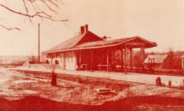
In the early years of the railroad, the 17.3 mile trip from Lincoln City to Rockport took one hour and twenty-two minutes to complete. Rockport was the eighth stop on the trip. In December 1874, we know that a special Saturday round trip fare for such a trip was $1.25. The line provided a means of transporting the products of the area to markets as well. The train carried coal, and a hogshead of tobacco could be shipped to Rockport for $1.75. The first railroad depot in Lincoln City was located west of the tracks, but sometime after 1892, a new depot was constructed in the fork between the main line and the Cannelton branch. The railroad dug a fourteen acre reservoir and built a water tower to supply the steam engines of the day with water. The pond was also used as a recreational area for the town’s residents.
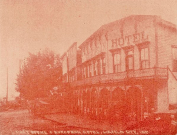
With the railroad came people and commercial enterprises. Stores were soon opened to supply the needs of residents and railroad workers. William Bender in partnership with William Gaines, A. Jeff Rhodes, John Lipsey, Will Van Winkle, and John Meier were early store owners of Lincoln City. Hotels were built in the town to accommodate the railway travelers. Perhaps the most impressive of these was the European Hotel and Restaurant located directly east of the second depot. About 1914 the Standard Oil Company built a bulk oil station on the railway right-of-way to supply the needs of changing modes of transportation.
At one time Lincoln City had twelve scheduled passenger trains, one every 30 minutes, stopping at the depot. Restaurants and saloons were popular with the travelers on these
trains, and Lincoln City had its share. This was especially due to the local option laws of the pre-prohibition era. Many area communities chose to be “dry” while Lincoln City opted to be very “wet.”
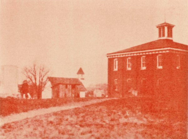
The first Lincoln City school was constructed in 1876. Then a large brick school was built around 1900, a few yards west of the site of the Lincoln Cabin. A young Abraham Lincoln probably never dreamed that seventy years after his departure, a railroad and a modern school would have been constructed within two hundred yards of the site of his frontier home. The school was moved once more after the State of Indiana ac quired the area to create a memorial to the Lincoln family in 1929. This time a school building was constructed a quarter• mile to the northeast. As in many small towns in Indiana, the school wa later closed as a result of school consolidation. However, in 1973, the four million dollar Heritage Hills High School was opened on the east side of Lincoln City to serve students of northern Spencer County.
While the Little Pigeon Baptist Church associated with the Lincoln era remained active south of the town limits, a United Brethren Church was organized in the town in the 1880s. For many years the building was located north of the Cannelton spur railroad on land once owned by the Lincolns. It too had to move with the development of the Nancy Hanks Lincoln Memorial; it was relocated just north of the Memorial grounds. This church later became the Lincoln Memorial United Methodist Church. The congregation disbanded and the building was dismantled in 1977 after the church property was purchased by the National Park Service.
Today little remains of what was once an active railroad town. The first blow to Lincoln City was a fire in 1911. Many of the commercial buildings, including the European Hotel were destroyed. Part of the town was rebuilt, but it never really recovered from the disaster. Later fires destroyed other business buildings, including the second railroad depot. A smaller depot was rebuilt after this fire.
A second factor contributing to the demise of Lincoln City was the decline of rail passenger service. The date of the last such service to the town is not recorded, but by mid-century the passenger trains and the depot had vanished. Today the tracks are still used as part of the Norfolk and Southern line. Lincoln City serves as a switching area for freight trains.
It is ironic that a final reason for the decline of the town is the reason why it became unique originally – Abraham Lincoln had once lived there. As more people came to Lincoln City, more curiosity was displayed about Lincoln’s Indiana years. There had been some early interest in marking the grave of Nancy Hanks Lincoln, but this was not accomplished until November 27, 1879. At this time the Cincinnati businessmen donated one-half acre of land around her grave to Spencer County to be preserved. This cemetery once again became active with a number of burials taking place in the late 1800s. As more interest was created in the cemetery area, the county purchased sixteen acres, all within the town limits, and a park was created. This park was very popular with area Sunday Schools for outings and with Civil War veterans for Grand Army of the Republic reunion encampments. In 1907 the Indiana General Assembly created a state-appointed board to look after the area, and in 1925 it transferred the property to the Indiana Department of Conservation. Frank C. Ball of Muncie, Indiana, purchased thirty acres of the town in 1929, including the cabin site and much of the Lincoln farm, and deeded it to the State. The tate removed all houses and buildings and developed the area as the Nancy Hanks Lincoln State Memorial. The state subsequently deeded the land to the National Park Service in 1962 in order to establish Lincoln Boyhood National Memorial. The National Park Service, in two land acquisitions in the 1960s and 1970s, acquired much of the remaining town.
Today, Lincoln City retains its importance on the map of Indiana; not as a lively railroad town, but as the “address” for the parks, memorials, and attractions which commemorate Abraham Lincoln’s Hoosier years. With the growing interest in these sites, the Lincoln City area should continue to be one of Indiana’s most popular destinations.