Pulaski County Democrat June 16, 1971
 The Town of Winamac was laid out with a long chain in the original survey, according to one 19th century expert.
Even more startling, no surveyor from 1866 on (and even prior to that according to written testimony) has succeeded in finding the ‘original survey’.
This is only one bit of Pulaskiana coming to light from work in progress now by the County’s Surveyor’s office.
An act passed by the state legislature in 1965 mandated that each county relocate, re-establish and re-witness all the corners and subdivision markers of sections in the county. The rate of relocation was established at 5 percent per year, with a 20-year deadline to complete the job.
The first relocations here were made under the supervision of former Surveyor John Sheppard. With the resignation of Sheppard in Feb. 1970, the work stopped, then resumed when William Butler was named part-time surveyor in February of this year.
Butler figures the job is about 30 percent completed and that some 1,700 markers must be found and re-established in the next 14 years.
Question: “Does the present relocation work anticipate solving Winamac’s non-existent survey lines?”
Butler: (with emphasis) “Negative”.
He went on to explain that the state has ordered only the relocating of county section corner and subdivision markers, but that this work could result in establishing a ‘point of origin’ for a re-survey (or, rather, ‘finding’ the original survey) of the Town of Winamac.
Winamac’s boundary problem is nowhere so explicitly and succinctly stated as in notations made in the Surveyor’s records by then Pulaski County Surveyor Russell Allen: one entered July 28, 1865, the other, March 16, 1866.
Here they are; spelling, punctuation and capitalization Allen’s.
“Survey made of Town Lots in the Town of Winamac will have to be made with an addition of 2 1⁄3 inches to each chain in consequence of the Chain with which the original Survey was made being that much too long–The South East corner of J P. Rowans Store Building being on Lot 39 is accepted as on the original Survey corner of the Town. This Point having been accepted by D. Agnew, and followed by Hawes. Front Street runs N 28 degrees 26 minutes West in 1865 July 28th”. (signed) Russell Allen S.P.C.
A plausible reconstruction of events after that entry indicates that Allen: 1. Tried to re-establish the original survey using a ‘long chain’ and, 2. Gave it up as an impossible job.
The next spring Allen entered this testimony in the record book:
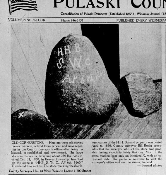
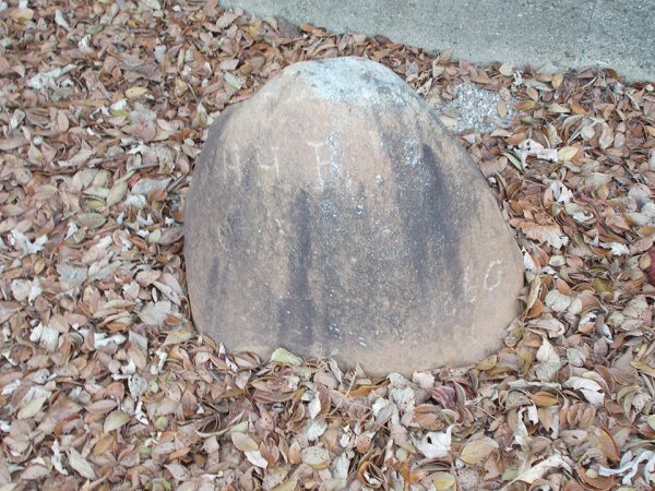
“In making further Surveys in the Town of Winamac, I find there has been a great error in which I find that I have, like my predecessor, failed in finding the original survey. At this time I find the record of the survey of the seminary lot on page 17 book. A surveyor’s record which gives a witness for the west Line of Market Street being the southeast corner of the seminary lot. I have deposited a stone at that point marked X. It will be found that the surveys made on Market street does not correspond with the above witness point. March 16, 1865” (signed) R. Allen S.P.C.
No one to this date has had any more luck than Allen.
Question: “How are sewer, water, utility lines, and such things established, then, in Winamac? With a string and a tape measure?
Butler: “That’s about it”.
In a general discussion of Winamac’s survey problem, Butler said that, by law, the original survey (If ever found) will take precedence over any lines established by common consent or custom since.
Bob Tolf, who has been spending his spare time lately assisting with the relocation project, is more hopeful today of eventually finding Winamac’s original corner markers than was Russell Allen a century ago. In fact, five have already been re-established since the work started in 1954. He and Don Cotner hope to turn up 11 more recorded points during the next two years.
Here are locations of the five recently found original stones.
- The center of Sec. 14, Monroe, at the Southwest corner of Crown Hill Cemetery.
- A city subdivision point on the east-west half section line of Sec. 14, Monroe, on the north edge of West Adams Street.
- The center of the west half of Sec. 13 on the west edge of Huddleston Drive.
- The center of the southwest quarter of Sec. 12, Monroe, at the northeast corner of the Decker Addition.
- A city subdivision point on the east side of the west half of the northeast quarter of Sec. 14, Monroe, on the east edge of East Street.
The original plat for Winamac was notarized by Henry P. Rowan on Jan. 22, 1840, but, Tolf pointed out it bore no surveyor’s signature nor were witnessed markers of any kind indicated on the plot.
Butler said that from time to time a fanciful story will make the rounds like: “The point of origin markers for Winamac were set in the river.” There is nothing in the record books, nor any other evidence to verify these tales, the surveyor said.
First Surveyor
One of the busiest men in these parts during the several years beginning with 1834 must have been Robert G. Hanna, who started making the original survey of this area for the Federal government that year. When the Pulaski County government was officially organized and established in 1839, Wm. H. Lemon became the County Surveyor. Surveyor’s Records dating back to Hanna’s original survey are still well preserved and legible in the Surveyor’s office,
Hanna first used posts to mark his section corners and half-mile points, county surveyors later going back to replace the posts with stones.
The markers are invariably plain field stones ranging in weight from 25 to as much as 250 lbs. The stones almost always are found inscribed with an X and often bear the date of placement. Many are found with their faces worn, apparently by the wagon wheels and dirt drags of the early days passing over them.
Time (and the lack of it) is the biggest obstacle in the relocating work, Tolf said. Almost all the original markers were witnessed by reference to a tree, a few by a post, another stone or some other natural feature. In the course of a century and a third, most of the witness trees have been obliterated.
“Hey, We Found One”
The old markers, of course, were buried on section corners, then property owners on either side of the lines each yielded 10 feet to provide for a road. Now the markers are found under asphalt, gravel or other road surfaces. Their locations are given away each spring after the winter’s frost has pushed them upwards to form a ‘bulge’ in the road surface.
“We’ll be driving along,” Butler said, “and hit a bump in the road. ‘Hey, I think we found one, we’ll say.’ So they jump out, start digging and usually find that they have, indeed, turned up another original marker. It’s rather like the pioneer aviators, who flew by the ‘seat of their pants.’”
Tolf said county highway grader operators, too, “have been very helpful in the cornerstone relocation by notifying us of stones in the roads.”
There is no evidence to show that Winamac was ever “founded.” During the earliest settlement, the site now occupied by the town lay astride both the Tippecanoe River and a crossroads and thus became a convenient and natural place for commerce. Like Topsy, it “just growed.”
The original 1840 plat included land of five different property owners.
The earliest Winamac property owners, apparently, did not concern themselves much with such details as accurate surveys; an oversight leading to today’s boundary difficulties. However, Butler said, many towns and cities in Indiana are plagued with the same problem–for whatever comfort that is.
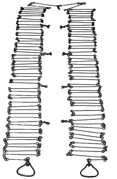
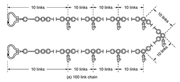
Gunter’s Chain
Source: eraconsultants.com/our-blog
Many property owners, engineers, planners, and developers have probably noticed some commonly odd measurements that often appear when measuring land and may have asked some of the following questions. Why is it common for a street right-of-way to measure 66 feet in width? Why are alleys commonly 16.5 feet wide? Why do we use acres to measure land area?
The Gunter’s Chain is a device that was first introduced in 1620 and was used to survey not only the British Empire, but also the wilderness and early American settlements. The Gunter’s Chain measures 66 feet in length and consists of 100 links usually marked off into groups of 10 by brass rings or tags. Though this device has become obsolete, it’s use has left an imprint on our nation’s history and how property has been measured and divided. The chain, the link, and the rod have all became statutory units of measurement that were made convenient by the Gunter’s Chain.
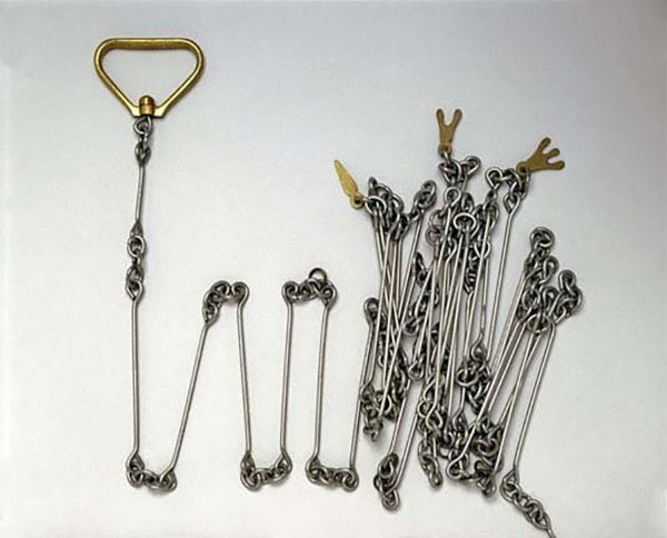
1 chain = 66 feet
1 link = 0.66 feet or 7.92 inches
1 rod = ¼ chain or 16.5 feet
1 furlong = 10 chains or 660 feet
1 mile = 80 chains or 5,280 feet
1 acre = 10 square chains or 43,560 square feet
Examples of Surveys and Use of Chains in Pulaski County from 1840s
Commissioners Record C June 1847 – Aug 1855 p40
December 9th, 1847
Whereas Thos. Buck, John March & George Kahler viewers appointed to view & locate a certain road commencing at or near the corner of Sections 30 & 31 in Town 29 R 2 West at the Rochester & Monticello Road Thence running in an easterly direction to the Tippecanoe & Logansport road & there to end. Having reported favorably to the location thereof as will more fully appear by the County Surveyors report & plat, which report and plat said Surveyor is ordered to file with the auditor within 10 days hereafter. It is therefore further ordered that said report of said viewers be confirmed & said road ordered to be opened to the width of forty feet & kept in good repair of which supervisors of highways will take notice.
Ordered that the following named persons by and they are hereby allowed the several amounts set opposite their respective names. To wit: John March, two days viewing $2.00; George Kahler, two days viewing $2.00; Thos. Buck one day viewing $1.00; Daniel Gemberling one day chaining $.75; Zachariah Reel, two days chaining $1.50; Francis A. Izard, one day chaining $.75; Carter D. Hathaway, two days surveying $3.00; platting $2.00; traveling one day $1.25.
Commissioners Record 1839 – 1847 p13
May Term May 3rd 1841
At the May term of the County Commissioners of the County of Pulaski began and held at the Clerk’s office in the Town of Winamac on the Third day of May A.D. 1841. Present Peter W. Demoss and John M. Cowan, Commissioners for Pulaski County, Indiana.
Ordered that the report of Comfort Olds and Jacob Phipps as Commissioners as appointed at the March term of this court to locate a county roade through Harrison Township be and is hereby Received and Filed.
Ordered that Comfort Olds and Jacob Phipps be allowed 3 dollars each for two days services rendered in locating that above mentioned roade.
Ordered that Isaac Olds be allowed four dollars and fifty cents for services rendered in surveying the above mentioned roade.
Ordered that two Chain Carriers and one Marker be allowed two dollars each for two days services rendered in the above roade, the said chain carriers and marker being William Collins, Benjamin Munson and Abraham Hathaway.
Commissioners Record 1839 – 1847 p14
May Term 1841
Pulaski County, April 28, 1841
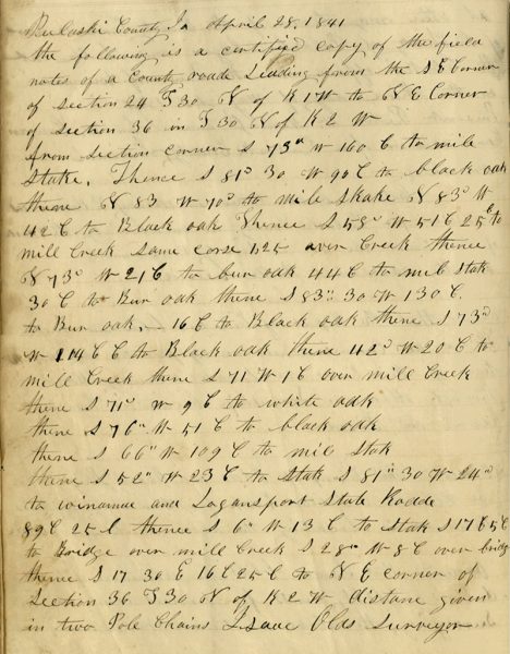 The following is a certified copy of the field notes of a county road leading from the SE Corner of section 24 T30 N of R1W to the NE corner of section 36 in T30 N of R2W.
- From section corner S 73° W 160 CH to mile stake.
- Thence S 81° 30 W 90 CH to black oak
- thence N 83 W 70° to mile stake N 83 CHA W 42 CH to Black oak
- thence S 58° W 51 CH 25 CH to Mill Creek same course, over Creek
- thence N 73° W 21 CH to bur oak 44 CH to mile stake 30 CH to bur oak
- thence S 83° 30 W 130 CH to bur oak
- thence 16 CH to black oak
- thence S 73° W 114 CH to Black oak
- thence 42 C W 20 CH to Mill Creek
- thence S 71 W 1 CH over Mill Creek
- thence S 71° W 9 CH to white oak
- thence S 76° W 51 CH to black oak
- thence 66° W 109 CH to mile stake
- thence S 52° W 23 CH to stake S 81° 30 W 24° to Winamac and Logansport State Road 89 CH 25 l
- thence S 6° W 13 CH to stake S 17 CH to Bridge over Mill Creek S 28° W 8 CH over Bridge
- thence S 17 30 E 16 CH 25 CH to NE corner of Section 36 T 30 N of R CH W
- distance given in two Pole Chains.
Isaac Olds, Surveyor