Before Pulaski County became Pulaski County (in 1839), the area had to be mapped and platted. These links contain the original plat maps, from 1834. From Indianamaps.org, this disclaimer is on the first page.
The purpose of this map is to assist in retrieving digitized PLSS notes and plats. The county and PLSS Township lines are for graphical reference only and do not represent true boundary or survey lines.
No attempt has been made in either the design or production nof this map to define the limits or jurisdiction of any federal, state, or local government. This map is intended for use only at the published scale of 1:24,000 or smaller and is for reference purposes only. It should not be construed as a legal document or survey instrument. A detailed on-the-ground survey and historical analysis of a single site will differ from this map. Your use of these files is an acceptance of these terms.
The linked images (and any subsequent modifications or derivatives) are forever in the Public Domain.
No business entity or person involved in the creation or distribution of this information make any warranty of any kind, expressed or implied, including but not limited to the accuracy, completeness, fitness, or usefulness of the map or the images for any particular purpose, and under no circumstances shall they be liable for any direct, indirect, incidental, consequential, special, exemplary, or punitive damages arising from or related to their use. Do not alter documents. Document names should not be changed. Document names describe the source and location of document location. Your access to (and/or use of) the map and images serves as your acceptance of these terms and conditions.
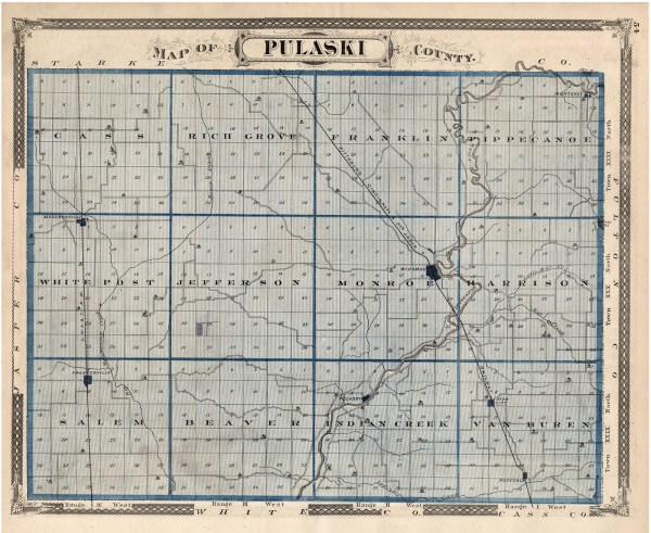
Townships, Starting at the Northwest Corner
Cass Township
Notes / Plats: httpsia601409.us.archive.org16itemsin-plss-federal-platsF_PM02T31NR04W_Plats_CassNotesPlats
Transcribed Plats: httpsia600407.us.archive.org12itemsin-plss-state-platsS_PM02T31NR04W_Plats_CassTranscribedPlats
Index: httpsia801405.us.archive.org23itemsin-plss-federal-notesF_PM02T31NR04W_Notes_CassIndex
Rich Grove Township
Notes / Plats: httpsia601409.us.archive.org16itemsin-plss-federal-platsF_PM02T31NR04W_Plats_CassNotesPlats
Transcribed Plats: httpsia800407.us.archive.org12itemsin-plss-state-platsS_PM02T31NR03W_Plats_RichGroveTranscribedPlats
Index: httpsia801405.us.archive.org23itemsin-plss-federal-notesF_PM02T31NR03W_Notes_RichGroveIndex
Franklin Township
Notes / Plats: httpsdn720004.ca.archive.org0itemsin-plss-federal-platsF_PM02T31NR02W_Plats_FranklinNotesPlats
Transcribed Plats: httpsia800407.us.archive.org12itemsin-plss-state-platsS_PM02T31NR02W_Plats_FranklinTranscribedPlats
Index: httpsia601405.us.archive.org23itemsin-plss-federal-notesF_PM02T31NR02W_Notes_FranklinIndex
Tippecanoe Township
Notes / Plats: httpsia601409.us.archive.org16itemsin-plss-federal-platsF_PM02T31NR01W_Plats_TippecanoeNotesPlats
Transcribed Plats: httpsia800407.us.archive.org12itemsin-plss-state-platsS_PM02T31NR01W_Plats_TippecanoeTranscribedPlats
Index: httpsia801405.us.archive.org23itemsin-plss-federal-notesF_PM02T31NR01W_Notes_TippecannoeIndex
White Post Township
Notes / Plats:httpsdn720004.ca.archive.org0itemsin-plss-federal-platsF_PM02T30NR04W_PlatsWhitePostNotesPlats
Transcribed Plats: httpsia600407.us.archive.org12itemsin-plss-state-platsS_PM02T30NR04W_Plats_WhitePostTranscribedPlats
Index: httpsia801405.us.archive.org23itemsin-plss-federal-notesF_PM02T30NR04W_Notes_WhitePostIndex
Jefferson Township
Notes / Plats: httpsdn720004.ca.archive.org0itemsin-plss-federal-platsF_PM02T30NR03W_Plats_JeffersonNotesPlats
Transcribed Plats: httpsia800407.us.archive.org12itemsin-plss-state-platsS_PM02T30NR03W_Plats_JeffersonTranscribedPlats
Index: httpsia801405.us.archive.org23itemsin-plss-federal-notesF_PM02T30NR03W_Notes_JeffersonIndexMaps
Monroe Township
Notes / Plats: httpsia801409.us.archive.org16itemsin-plss-federal-platsF_PM02T30NR02W_Plats_MonroeNotesPlats
Transcribed Plats: httpsia800407.us.archive.org12itemsin-plss-state-platsS_PM02T30NR02W_Plats_MonroeTranscribedPlats
Index: httpsia601405.us.archive.org23itemsin-plss-federal-notesF_PM02T30NR02W_Notes_MonroeIndex
Harrison Township
Notes / Plats: httpsia801405.us.archive.org23itemsin-plss-federal-notesF_PM02T30NR01W_Notes_HarrisonIndex
Transcribed Plats: httpsia801409.us.archive.org16itemsin-plss-federal-platsF_PM02T30NR02W_Plats_HarrisonTranscribedPlats
Index: httpsia801405.us.archive.org23itemsin-plss-federal-notesF_PM02T30NR01W_Notes_HarrisonIndex
Salem Township
Notes / Plats: httpsia801409.us.archive.org16itemsin-plss-federal-platsF_PM02T29NR04W_Plats_SalemNotesPlats
Transcribed Plats: httpsia800407.us.archive.org12itemsin-plss-state-platsS_PM02T29NR04W_Plats_SalemTranscribedPlats
Index: httpsia801405.us.archive.org23itemsin-plss-federal-notesF_PM02T29NR04W_Notes_SalemIndex
Beaver Township
Notes / Plats: httpsdn720004.ca.archive.org0itemsin-plss-federal-platsF_PM02T29NR03W_Plats_BeaverNotesPlats
Transcribed Plats: httpsia600407.us.archive.org12itemsin-plss-state-platsS_PM02T29NR03W_Plats_BeaverTranscribedPlats
Index: httpsia601405.us.archive.org23itemsin-plss-federal-notesF_PM02T29NR03W_Notes_BeaverIndex
Indian Creek Township
Notes / Plats: httpsdn720004.ca.archive.org0itemsin-plss-federal-platsF_PM02T29NR02W_Plats_IndianCreekNotesPlats
Transcribed Plats: httpsia800407.us.archive.org12itemsin-plss-state-platsS_PM02T29NR02W_Plats_IndianCreekTranscribedPlats
Index: httpsdn720006.ca.archive.org0itemsin-plss-federal-notesF_PM02T29NR02W_Notes_IndianCreekIndex
Van Buren Township
Notes / Plats: httpsdn720004.ca.archive.org0itemsin-plss-federal-platsF_PM02T29NR01W_Plats_VanBurenNotesPlats
Transcribed Plats httpsia800407.us.archive.org12itemsin-plss-state-platsS_PM02T29NR01W_Plats_VanBurenTranscribedPlats
Index: httpsdn720006.ca.archive.org0itemsin-plss-federal-notesF_PM02T29NR01W_Notes_VanBurenIndex
Rather Than Navigate Individual Links:
This site has easier to see original plats. Just click on the township you want and then click “Federal Plats
link”. https://www.indianamap.org/apps/ce66f46fa49643abba4e8d02af5ed4df/explore
Links to Additional Maps
This 1911 Plat Map is easy to read. You can easily make the map larger on the page. Landowners are shown.
This link takes to you an 1876 map.
Links from Our Own Website
The following links lead to additional history connected to the beginnings of Pulaski County.
Physical Features:
Pulaski County was formed by glaciers. This page provides information of the millions of years that shaped its topography.
Drainage:
The drainage of marshland is foundational to the shaping of Pulaski County’s farmland.
Pulaski County Takes Shape:
This page is from our series on Native Americans.